

What if seeing a vehicle’s live location still didn’t tell you whether it had reached the right site? If you’re asking “what is a geofence?”, the key difference is that it sets a virtual boundary around a real-world place and can record or signal when a tracked vehicle or asset crosses it. Live GPS tracking shows location; geofencing helps make specific movements easier to notice.
That can be useful for fleet and asset managers when the boundary reflects a real operational need and the resulting alert prompts a clear response. Poorly placed boundaries or unsuitable alert settings can create noise rather than useful oversight. Location data should also be handled thoughtfully, with clear rules about who can access it and why.
This guide explains how geofences work, how they differ from live tracking and where they may support oversight of business vehicles, plant and equipment. It also covers practical steps for setting boundaries, managing alerts and using location information responsibly, so you can assess how geofencing could fit into wider vehicle and asset tracking workflows.
Key Takeaways
- Understand what is a geofence and how location events can support practical oversight of vehicles and business assets.
- Follow the steps from defining an area and selecting assets to setting event rules and reviewing alerts.
- See how site arrivals, unexpected movement and asset location oversight apply to different fleet workflows.
- Start with a small number of purposeful zones, then refine boundaries and alert settings based on what the results show.
- Use geofencing alongside tracking information and operational records, not as a substitute for wider fleet processes.
What is a geofence? A clear definition for fleet and asset managers
A geofence is a virtual boundary drawn around a real-world location on a digital map. When location data from a tracked vehicle or asset indicates that it has crossed this boundary, the crossing can trigger a configured event, such as an alert or a location record. In brief, what is a geofence? It’s a map-based rule that makes movement into or out of a chosen area meaningful to an operation. The Geofence overview offers further background on the concept and its wider applications.
For example, a business could define a boundary around a work site and set up an event to flag when tracked equipment leaves it. The event doesn’t establish why the equipment moved or what action is needed. It brings the movement to a manager’s attention so they can review it alongside work schedules and asset records.
How is a geofence different from GPS tracking?
GPS is one source of location data. Tracking uses location information to show where an asset is, while a geofence applies a rule to that information: has the asset entered or left a specified area? A tracked vehicle can therefore be monitored without generating a geofence event if it hasn’t crossed a boundary configured to trigger one.
The result depends on the boundary, the event rules and the system’s behaviour. Different systems may handle location updates or crossings differently, so don’t assume a geofence works identically across every platform. Tracking answers “where is it?” A geofence can help answer “has it crossed this defined line?”
What can a geofence surround?
A boundary can be drawn around a place that matters to day-to-day operations, such as a depot, customer site, work zone or equipment storage area. Depending on how the mapping system defines areas, the outline may follow a simple radius or a more closely mapped shape. Choose an area that reflects the real location and purpose, rather than an arbitrary point on a map.
Possible tracked assets include business vehicles, plant and machinery tracking. A fleet manager might use a site boundary to review vehicle arrivals, while an equipment manager could monitor whether machinery appears to leave a designated work area. Geofencing helps organise location information around specific places; it works best when the area and intended response are clear.
How does a geofence work? From map boundary to location alert
The question “what is a geofence?” becomes easier to answer when you follow the process: a mapped area is linked to a tracked asset, and chosen rules determine what happens when location data shows it crossing the boundary. The crossing is detected from location data, not by a physical barrier, so an alert is an operational prompt rather than proof of why the asset moved.
A typical setup follows four steps:
- 1. Define the area. Mark the location that matters, such as a depot entrance or equipment storage area.
- 2. Select an asset. Apply the area to the relevant tracked vehicle, plant or machinery.
- 3. Set event rules. Choose which movement matters, such as entry, exit or both, if those options are available in the system.
- 4. Receive and review alerts. Check the event in context, using operational plans or asset records to decide whether action is needed.
How are geofence boundaries created?
A circular boundary uses a chosen point and radius to define an area. A custom mapped shape follows a specific outline, which can be more suitable when a site has an irregular layout or nearby roads and land should be excluded. Match the boundary to the site and the task: a depot arrival alert may need to focus on the entrance, while an equipment storage zone should reflect the area where machinery is expected to remain.
For example, a manager monitoring equipment at a depot could map the storage yard rather than draw a broad circle around the surrounding area. A boundary that is too wide may flag movement that needs no attention; one that is too tight may miss relevant crossings. Treat the first map setting as a starting point, then review it against real site conditions.
What happens when a tracked asset crosses the boundary?
When location updates indicate that an asset has entered or left the defined area, the configured rule may record the event or generate a notification. Entry and exit can be treated as separate events if the system allows it. A notification can help a manager notice movement, but it doesn’t explain whether a vehicle was dispatched, a machine was relocated or the position data needs checking.
Systems differ in how often they receive and process location updates, and alert delivery and reporting depend on configuration. An alert may not appear at the precise moment an asset crosses a mapped line. Match the boundary and event settings to the operational task, then review whether the notifications are useful. For a wider view of location-led oversight, explore vehicle and asset tracking.
What are geofences used for, and what are their limitations?
Geofences can make location data more useful by drawing attention to movement that matters to an operation. A site arrival or departure event may help teams organise records, while unexpected movement can prompt a dispatch or security review. The value is in creating a timely cue for staff, not in treating every alert as a complete account of what happened.
Different assets call for different workflows:
- Vehicles: Arrival and departure events at customer sites may help teams review schedules, movements and operational records.
- Plant and machinery: A boundary around a work zone can support oversight of where equipment is expected to be and flag movement for follow-up.
For businesses managing equipment across active projects, a construction asset tracking guide can help put location oversight into a broader operational context. Geofencing can contribute to awareness, but it doesn’t physically prevent theft or establish that a vehicle or machine has been stolen.
When can geofences help monitor vehicles and assets?
A recorded vehicle arrival may help a team compare site activity with planned work, while a departure outside expected timings could be a reason to review dispatch information. For machinery, an unexpected boundary event may prompt someone to check project plans or contact the relevant team. These events support operational reporting and follow-up, but their meaning depends on context. A location event alone isn’t proof of a breach, theft or driver action.
Why might a geofence create an unexpected alert?
Location estimates can vary, particularly near buildings, inside enclosed spaces or where signals are obstructed. Update frequency also affects when a crossing is detected, and a boundary drawn too tightly may create alerts that need investigation rather than immediate action. If a vehicle appears just outside a mapped area, that doesn’t by itself confirm an unauthorised departure. Review the location information alongside site layout, timing and operational records before deciding what happened.
So, what is a geofence able to tell a manager? It can indicate that location data suggests an asset crossed a defined boundary, subject to signal conditions, update timing and the system’s configuration. It isn’t guaranteed proof of an asset’s exact position or the reason for its movement. Treating alerts as prompts to check, rather than definitive conclusions, helps teams gain useful oversight without mistaking an imperfect location event for certainty.
How to set up geofences that produce useful fleet alerts
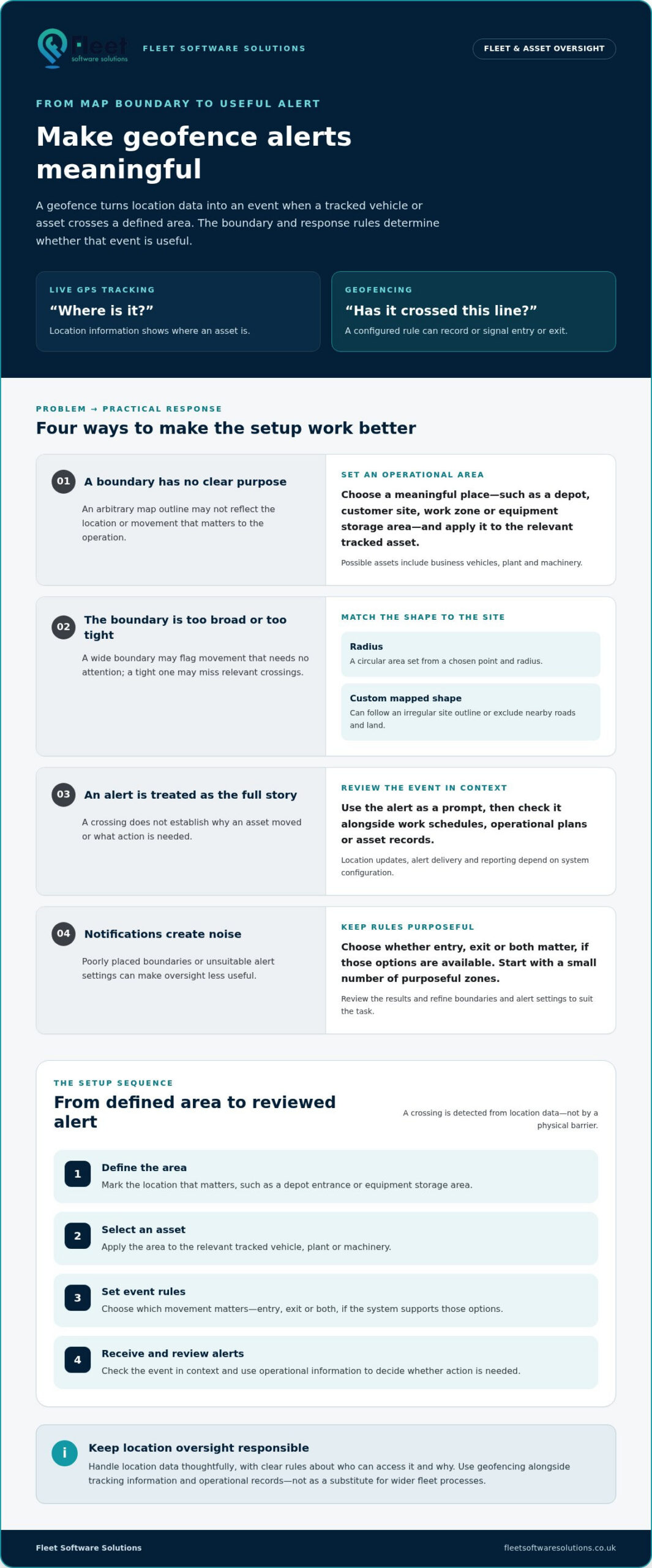
A useful geofence starts with an operational question, not a map full of boundaries. Decide what movement matters and who needs to respond. Then create a small number of purposeful zones, review the results and refine them before expanding. This keeps notifications tied to decisions rather than adding noise to an already busy workflow.
Use this sequence to plan each zone:
- Define the purpose. Specify what the boundary should help you understand, such as whether a vehicle reached a work site or machinery left a storage area.
- Map the area. Match the outline to the site and the question the event needs to answer.
- Select relevant assets. Include only the vehicles, plant or equipment for which the zone is meaningful.
- Choose the event. Decide whether entry, exit or another available event warrants review.
- Review the results. Check whether alerts arrive usefully and reflect actual operating patterns, then adjust settings where possible.
Start with a few high-value locations, such as a depot or regularly used work site, rather than mapping every destination at once. For broader context on location oversight, read this business vehicle tracking guide.
How should a business choose a geofence boundary?
Begin by asking what decision the boundary should support. If the aim is to review whether an asset reached a site, map the smallest practical area that reflects the site layout and the intended decision. A boundary that is too broad may register nearby movement as relevant; one that is too tight may produce events that require repeated investigation.
Check the mapped outline against the real operating environment before relying on its alerts. Consider entrances, adjoining roads, buildings and where vehicles or equipment are expected to move. The right boundary is practical, not simply precise-looking on screen.
How can teams keep alerts actionable?
Assign clear ownership: decide who reviews each type of notification, what information they should check and how relevant events are recorded or escalated. This reduces the risk of duplicated follow-up or alerts that nobody considers their responsibility. Review recurring notifications with the people who use the information. If they repeatedly create unnecessary work, adjust boundaries or rules where possible.
Location information also needs responsible handling. Explain monitoring transparently to affected staff, limit access and use to appropriate operational purposes, and follow your organisation’s privacy and data governance processes. Check current guidance from the UK Information Commissioner’s Office (ICO) when deciding how location data should be managed.
For an organised approach to vehicle and asset oversight, explore business vehicle and asset tracking alongside the processes your team uses to review location events.
How geofencing fits into fleet and asset tracking
A geofence is one layer of location monitoring, not a replacement for live vehicle or asset tracking, accurate records or the operational processes that guide decisions. Tracking can provide location information; a geofence can make a particular movement relevant by linking it to a defined place. Staff then need to interpret that event alongside schedules, vehicle or asset records and the work taking place.
For example, a location event showing a vehicle at a work site may help a team review planned activity, while an unexpected movement of machinery could prompt a check against project records. The event is a starting point for review, not a decision in itself. Its value depends on a clear response: who considers it, what context they check and how they record any follow-up.
How do geofences relate to wider fleet management?
Geofence events can sit alongside vehicle tracking and wider fleet information, helping teams connect location with operational context rather than treating it as an isolated notification. A site arrival may be useful when considered with a vehicle’s planned work; an asset movement may need to be checked against its allocation. For more on how information supports broader fleet oversight, read this fleet management guide.
What should a business consider next?
Start by identifying which vehicles or assets need oversight, which locations matter and what decisions location information should support. Then review how tracking records are used, who owns alert follow-up and how location data is managed. These practical steps help keep monitoring proportionate and ensure that a location event has a clear place in the workflow.
In short, asking “what is a geofence?” is only the beginning. The more useful question is how a defined boundary and its resulting event can support your team’s everyday decisions. Business vehicle and asset tracking can provide a wider framework for organising location information; explore business fleet and asset tracking to see how tracking can support operational oversight.
Make location data work for your operation
Understanding what is a geofence helps clarify how a virtual boundary can add context to vehicle and asset location data. It marks an area and can flag a configured crossing, while tracking provides location information. Used together thoughtfully, they can help managers review site arrivals, departures and unexpected movements.
The practical value depends on more than drawing a boundary. Choose zones that reflect real operational needs, set relevant event rules and decide who will review notifications. Location signals and update timing can affect what an alert shows, so treat it as a prompt to check the wider context, not definitive proof of what happened. Clear ownership and responsible handling of location information help keep oversight useful.
Fleet Software Solutions provides business-focused vehicle and asset tracking, alongside fleet management software, vehicle cameras and plant and machinery tracking. Explore Fleet Software Solutions’ business fleet and asset tracking solutions to see how location information can support your operational workflows.
Frequently Asked Questions
What is a geofence in simple terms?
A geofence is a virtual boundary drawn around a real-world place on a digital map. If location data indicates that a tracked vehicle or asset crosses it, a configured system may record the event or send a notification. For example, a boundary around a storage yard could help a manager notice that tracked machinery appears to have left the area. It’s a digital rule, not a physical barrier.
How does a geofence work with GPS tracking?
GPS can provide location data, and a geofence applies a rule to that data. A system compares an asset’s reported position with a mapped boundary and may register an entry or exit event if the relevant rule is configured. For instance, a vehicle’s location may be tracked without generating an alert unless it crosses a boundary linked to an event. Update timing and system settings affect what users see.
Can a geofence track a vehicle in real time?
A geofence doesn’t track a vehicle by itself; it defines an area against which location data can be assessed. A tracking system may provide current or near-current location information, depending on how often it receives and processes updates. If a vehicle crosses a configured boundary, an event may be reported after the relevant location update. Check the timing and context of an event before treating it as an exact live position.
What happens when a vehicle enters or leaves a geofence?
When location data indicates that a vehicle has crossed a defined boundary, the system may record the crossing or send a notification, depending on its settings. Entry and exit events may be configured separately where supported. A depot arrival alert, for example, could help a team review vehicle movements against its records. The notification indicates a location event, but doesn’t establish why the vehicle moved or prove a particular action.
How accurate is a GPS geofence?
A GPS geofence’s accuracy depends on the location data available, the system’s update frequency and how the boundary is drawn. GPS can be less reliable indoors, near tall buildings or where signals are obstructed, so a reported position may vary. A boundary that’s too tight for the site may also prompt events that need checking. Treat alerts as useful indicators, and review them alongside site conditions and operational records.
Can geofencing be used to monitor plant and machinery?
Yes, geofencing can be used with tracked plant and machinery where the tracking system supports location-based boundaries. A manager might define a work zone or storage area and review an event if equipment appears to enter or leave it. This can help organise asset oversight, but a location event isn’t proof of theft or the reason for movement. Check it against project plans, asset records and the circumstances at the site.
Is geofencing allowed for employee vehicles in the UK?
Employee vehicle monitoring may be appropriate where there’s a clear business purpose, but organisations should consider UK data protection requirements before using location information. Identify and document an appropriate lawful basis, explain monitoring clearly to affected staff, and collect only information that’s necessary and proportionate to the purpose. Consider access, retention and whether a data protection impact assessment is needed. Consult current Information Commissioner’s Office guidance for your circumstances.
What is the difference between geofencing and GPS tracking?
GPS tracking reports a vehicle or asset’s location; geofencing defines an area and applies a rule to location data about crossing it. Tracking can show where a vehicle is without any boundary event being triggered. A geofence can help draw attention to a particular arrival or departure, if the relevant rules are configured. Used together, they provide location information and a way to flag movements for operational review. For how location data can contribute to safer fleet driving while remaining only one part of the picture, see this vehicle tracker guide to supporting safer fleet driving.


